Research
Mar 22-28, 2015 Potsdam-Golm
Research within ALErT tries to deliver answers on the interaction between tectonic and climatic processes, which influence the morphologic evolution of the Central Anatolian Plateau (CAP) in Turkey and associated natural hazards. To understand how the margins of the Central Anatolian Plateau evolve, and to assess the hazards of this region, we will decipher the underlying mechanisms, feedbacks, and rates of tectonic, climatic, hydrologic, and erosional processes over a wide range of timescales.
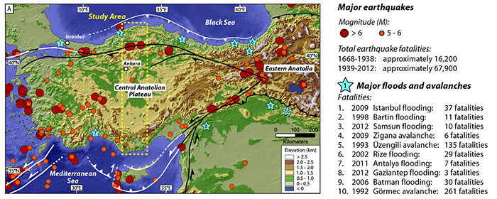
Figure: Earthquakes and recent natural disasters in the study area of Turkey
We have designed an integrative approach that spans the study of geological archives and present-day monitoring. On their own, geoarchives offer an incomplete record of Earth’s history, but we can integrate records of past processes with information about active processes provided by observational, analytical, and computational methods. These methods span the fields of geology, geophysics, remote sensing, meteorology, and surface processes.
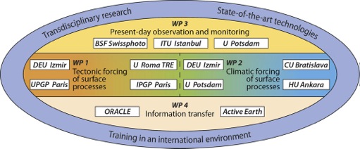
Research is broken into four transdisciplinary, linked work packages (WPs 1-4, referring to the main research objectives) and associated research task, which are identical to the 15 individual research projects (see table below).
The work packages entail:
(
WP1
) Tectonic impacts on surface processes:
Deciphering the impact of faulting on erosion and plateau-margin evolution at different time scales.
(
WP2
) Climatic impacts on surface processes:
Characterizing the interaction between erosion and climate-driven processes in the past.
(
WP3
) Present-day observations and monitoring:
From earthquakes and paleoseismology to the analysis of recent deformation and hydrometeorological events.
(
WP4
) Information transfer and communication:
Devising novel strategies for the retrieval and presentation of heterogenous and large quantities of data.
Research tasks will focus on the following topics:
( Task 1.1, ESR 1, Uni Roma )
Late Cenozoic deformation, uplift, and erosion along the southern flank of the Anatolian plateau: the terrestrial record. At the southern margin of the CAP, Neogene carbonates record long term topographic growth, while younger fluvial strata and marine terraces provide datable reference horizons that have been elevated during plateau-margin uplift. With new observations of the Quaternary uplift and deformation history, we will integrate an understanding of processes over the past 10 4 to 10 5 years with the long-term geodynamic setting of the plateau margin. This project is linked to tasks 2.2 and 1.3.
( Task 1.2, ESR 2, Dokuz Eylül University , Izmir)
Late Cenozoic deformation, sedimentation, and basin evolution of the southern CAP margin: the marine record. Offshore seismic data from the Cilicia Basin will reveal the geometry of faults along the Anatolian plateau’s southern margin, the history of deformation, and changes in the amount of material eroded and deposited through time. Together with changes in the volume of material deposited through time, the data will show how erosional and depositional processes have responded to plateau-margin growth through time. This project is linked to task 1.1.
( Task 1.3a and b, ER1, ESR 3, Institute of Earth Physics of Paris )
Deformation of the Anatolia-Aegean margins associated with changes in plate-boundary conditions: dextral North Anatolian Fault and subduction at the Hellenic Arc. Uplift of the CAP is intimately associated with the westward extrusion of the Anatolia-Aegean Block, the westward growth of the North Anatolian Fault, and changing subduction conditions at the Hellenic Arc. A detailed study of uplifted features on land (from uplifted marine basins and terraces) will be combined with TOTAL’s seismic data. This task is with linked with tasks 2.3, 1.1 and 1.2, and 3.3.
( Task 2.1, ESR 4, Universität Potsdam )
Holocene paleo-erosion rates in light of climate variability. To understand tectonic and climatic forcing on landscape evolution over millennial timescales we must decipher how climate affects erosion and sedimentation through a rigorous analysis of geoarchives. We will measure paleo-erosion rates associated with anomalous climatic periods in the past, which when compared to modern observations, can provide an empirical set of observations to compare present-day processes to past environmental conditions. This project is linked to tasks 2.2, 1.1 and 1.2.
( Task 2.2, ESR 5, Hacettepe University , Ankara)
Evolution of drainage networks and Quaternary sedimentary records of the northern margin of the CAP. Intermontane basins along the northern margin of the CAP, in addition to being primary targets of interest for petroleum industry, provide a sink for sediments to accumulate within the orogen and a storage area for easily eroded material if climatic/tectonic conditions change. We will assess geologic archives in these sensitive recorders of change. This task is linked to tasks 2.1, 2.3 and 2.4.
( Task 2.3, ESR 6, Dokuz Eylül University , Izmir)
Late Cenozoic sedimentation and basin evolution of the northern CAP margin: the marine record. Offshore seismic data from the Black Sea Basin will reveal the geometry and thickness of sediments along the CAP’s northern margin. This sedimentary record is intimately linked with changes in precipitation and erosion associated with plateau margin growth, as the numerous terrestrial basins along the plateau’s northern margin comprise a set of easily eroded regions. This project is associated with tasks 2.2 and 2.4.
( Task 2.4, ESR 7, Comenius University , Bratislava)
Paleoclimate records from lakes throughout the CAP. Pollen and sedimentologic analyses from lake sediments can provide detailed information on past changes in vegetation and erosional processes, which are directly linked with climate. Over medium timescales, these records can be associated with glacial-interglacial cycles, while over longer timescales, the changes should reflect the influence of growing orographic barriers on precipitation patterns. This project is linked to tasks 2.2 and 2.3.
( Task 3.1, ESR 8, Istanbul Technical University )
Deformation and earthquakes along the modern plateau margins. Since 1999, Turkey has installed a series of 34 permanent GPS stations in the high-strain regions of the country. The high resolution record of both horizontal and vertical movements available from these stations, together with shorter campaign-style geodetic data, can help fill the critical spatial and temporal gaps between longer term deformation records from geologic archives and the recent, highly localized record of crustal strain from earthquakes. This project will be linked to tasks 1.1 and 1.3.
( Task 3.2, ESR 9, Universität Potsdam )
Rainfall-extreme events, flooding, erosion, and sediment-transport processes along the flanks of the Anatolian Plateau. Spatiotemporal variability of extreme rainfall events along the flanks of the CAP frequently results in flooding. Associated run-off transfers large quantities of sediment from hillslopes to the intermontane basins and beyond. We will assess present-day hydrologic data and measure modern erosion rates to determine how rainfall modulates erosion processes on short timescales. This project is linked to task 2.1.
( Task 3.3, ESR10, BSF Swissphoto GmbH , Schönefeld, Germany)
Creation of an interactive natural hazard database for northern flank of the Anatolian Plateau. A database of the spatial and temporal context of natural hazards is the first step in identifying vulnerable areas. A GIS database will be created that links administrative, political, and social datas with geoscience data. Our access to high-resolution aerial imagery and radar imagery from TerraSAR-X will ensure that the most technologically advanced data are used. Changes in vegetation associated with changing climatic conditions, which is critical for identifying recent changes in hazard levels and predicting future changes, can be effectively identified.
( Task 4.1, ESR 11, Plymouth University )
Development of geological visualization tools. Current geological datasets of the subsurface are analyzed by specialists using sophisticated geo-visualization technologies. Conveying the key elements of such complex 3-D geological environments is problematic, especially when communicating with non-specialist stake-holders. We will develop transdisplinary research links with the digital arts by building on technological contributions from the Virtual Reality / Augmented Reality / ‘Serious Games’ arena to develop intuitive representations of the geological subsurface. The project is linked to tasks 3.1 and 3.2.
(
Task 4.2,
ER 2,
ORACLE
, Potsdam)
Spatial analytics and Accessibility of knowledge from integrated databases. Heterogeneous, complex data including seismicity, fault kinematics, GPS measurements, and modern hydrology generated in WPs1 and 3 will be integrated into a database. Transformation of the data and generation of pertinent knowledge is the focus of this integrated approach, which links Informatics and Geosciences. The recruited ER will focus on statistical programming, application and development of spatial semantics, analysis, and visualization. He/she will collaborate with experts in WP1 and 3 to enable faster data processing and analysis, especially of large data sets, and provide solutions for an effective presentation of complex data sets.
Overview of work packages and tasks:
Relevant
WPsProject Title Host Institution Res. No. WP1
Task 1Late Cenozoic deformation, uplift, and erosion along the southern flank of the CAP: the terrestrial record UniRoma3 ESR1 WP1
Task 2Late Cenozoic deformation, sedimentation, and basin evolution of the southern CAP margin: the marine record The southern margin of the Central Anatolian Plateau preserves a layered archive where deformation, sedimentation, and basin evolution are recorded together in the marine sedimentary record. Researchers working in this region investigate how tectonic forces shape the edges of the plateau over late Cenozoic time, while surrounding seas accumulate sequences of clastic and biogenic material that respond to both structural growth and climatic shifts. By correlating onshore structures with offshore stratigraphy, the project builds an integrated picture of how the margin has evolved through changing boundary conditions, linking deep Earth processes to the surface environments that fringe one of the Mediterranean's most rapidly changing landscapes.
Marine sediment cores retrieved from basins along this margin offer a continuous record of environmental change that complements the fragmentary evidence preserved on land. Variations in grain size, composition, and microfossil assemblages reflect shifts in sediment supply driven by uplift and erosion of the plateau, as well as changes in oceanographic conditions and climate. Researchers within the network analyze these signals to disentangle tectonic from climatic forcing, an essential step toward understanding how the Anatolian region has responded to both mountain building and shifting atmospheric and oceanic circulation patterns over millions of years.
Late Cenozoic basin evolution along the southern Central Anatolian Plateau margin reflects the interplay between active faulting, regional subsidence, and sedimentation patterns controlled by sea level and climate. Tectonic structures bounding the margin influence accommodation space and sediment routing, guiding the dispersal of material eroded from the high plateau into adjacent marine basins. Through field studies, seismic interpretation, and laboratory analyses, the research characterizes the timing and rates of deformation, the architecture of sedimentary fills, and the way basin geometry records the gradual growth of the plateau margin through time.
The investigation of the southern margin contributes directly to broader questions about natural hazards in the region. Active faults, folded strata, and rapidly deposited sediments all influence slope stability, earthquake recurrence, and landscape response to environmental change. By reconstructing the long-term behavior of the margin and the basins that fringe it, scientists gain a deeper baseline for assessing present-day tectonic and climatic hazards that affect densely populated communities living near the boundary between land and sea. This long-term perspective is essential for grounding modern hazard monitoring in a robust geological context.
As part of a Marie Curie Initial Training Network, this research strand also plays a central role in training early career researchers across European academic and industry partners. Students and postdoctoral fellows engage with multidisciplinary methods that combine structural geology, sedimentology, geophysics, and climate science, developing skills that span academic and applied fields. Working within a virtual campus that links universities, extramural research departments, and affiliated institutions, participants learn to integrate diverse datasets and approaches. This combination of frontier science and structured training equips the next generation of geoscientists to address natural hazard and environmental challenges in rapidly changing regions such as the Central Anatolian Plateau.
DEU Izmir ESR2 WP1
Task 3aDeformation of the Anatolia-Aegean margins associated with changes in plate-boundary conditions (part a) IPGP Paris ESR3 WP1
Task 3bDeformation of the Anatolia-Aegean margins associated with changes in plate-boundary conditions (part b) IPGP Paris ER1 WP2
Task 1Climate impacts on Holocene paleo-erosion rates UP ESR4 WP2
Task 2Evolution of drainage networks and Quaternary sedimentary records of the northern margin of the CAP HU Ankara ESR5 WP2
Task 3Late Cenozoic sedimentation and basin evolution of the northern CAP margin: the marine record DEU Izmir ESR6 WP2
Task 4Paleoclimate records from lakes throughout the CAP CU Bratislava ESR7 WP3
Task 1Recent deformation and earthquakes at the CAP margins ITU Istanbul ESR8 WP3
Task 2Rainfall-extreme events, flooding, erosion, and sediment-transport along the CAP flanks UP ESR9 WP3
Task 3Creation of an interactive CAP natural-hazard database Swissphoto ESR10 WP4
Task 1Development of geological visualization tools Active Earth ESR11 WP4
Task 2Spatial analytics and Accessibility of knowledge from integrated databases ORACLE Munich ER2